Better understanding and sustainable use of Lusatian soils
The two-year project , which is funded by the Federal Ministry for the Environment, Nature Conservation, Nuclear Safety and Consumer Protection (BMUV) with around 360,000 euros, aims to raise awareness of sustainable land use and better soil protection in the Lusatian mining district.
Soil is thus being acknowledged for its special importance and brought into the public eye - as the basis of life for humans and animals, but also as the foundation for everything that is created on it. Under the premise "Only those who know its importance and quality can use and protect it properly", agricultural land and recultivated soils in post-mining landscapes are considered equally.
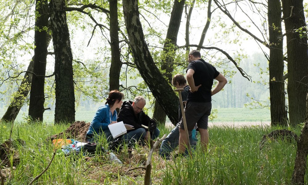
Dr. Steffi Schillem, research assistant in the Citizen Science project, says: "The focus is on interest in nature conservation. We invite anyone who would like to participate to do so. Our project thrives on citizen participation and our guiding principle is: Discover with us what you are interested in!". Project employee and soil scientist Juliane Klemm adds: "Taking part is easy and exciting at the same time: under our guidance, interested parties learn how to take soil samples, how to evaluate them and what findings can be drawn from the relevant parameters. We offer an introductory workshop in April and provide a free mobile app for practical soil analysis in spring and summer. We will then evaluate the results together in the fall. We will remain in dialog with our helpers throughout the entire process."
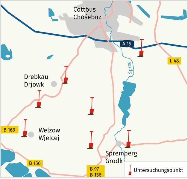
Information events in Cottbus, Welzow, Drebkau and Spremberg
will explain to all interested parties what the joint work is about and what the specific tasks of the participants are. To this end, BTU scientists from the Research Center for Landscape Development and Post-Mining Landscapes (FZLB) will be coming to the locations where the investigations are to take place.
The first dates are:
- Monday, January 22, 2024 in Cottbus: 5-6 p.m., Universitätsstraße 22;
- Monday, January 29, 2024 in Drebkau: 5-6 p.m., Drebkauer Kochtopf, Schwarzer Weg 110
Dates in Welzow and Spremberg are planned for the end of February/beginning of March.
Practical workshops on soil identification and detailed instructions provide the new team members with the necessary tools in a second step: initial samples are assessed using a test kit and a mobile app. Afterwards, small teams go on expeditions on site. A total of around 100 test points have been selected for which you can choose. The test results are collected in an online map of soil quality. They are intended to provide information for sensible land use: for the timber industry, as agricultural land or for renewable energy generation using photovoltaics and wind power. The soil quality map forms the basis for further discussions with local communities, landowners and land users in order to discuss, with public participation, how Lusatian soils are doing and how they can be used sensibly.
Background
Decades of coal mining have left their mark on the Lusatian mining district. As in other lignite mining areas, open-cast mining operations have changed and destroyed naturally grown soils on a massive scale. Even today, the soil quality in the post-mining landscapes is still poor in many places, and the soils are usually not productive enough for agricultural use.
For the project "Mapping soil quality in the Lusatian mining district", the BTU Cottbus-Senftenberg is using "Citizen Science"to create soil quality maps together with citizens. The investigations are carried out using a standardized soil evaluation procedure. Using a specially developed web application, the citizens involved can independently collect their own data on the quality of naturally grown soils compared to the soils of post-mining landscapes. Experts from the university are providing scientific support for the project. The participating volunteers are supported with events and workshops. The resulting maps will be made available to the public free of charge via an online portal.
The project is based on cooperation between science, environmental associations, IT consultants and local authorities. Ideal cooperation partners are the DigitalAgentur Brandenburg (DABB), the Naturschutzbund Deutschland (NABU) and the Bund für Umwelt und Naturschutz Deutschland -Landesverband Brandenburg (BUND). Associations and municipal representatives from the districts of Spree-Neiße and Oberspreewald-Lausitz, as well as from the independent city of Cottbus, are also involved.
Further information: https://boden-entdecken.de/.
Contact us
Forschungszentrum Landschaftsentwicklung und Bergbaulandschaften (FZLB)
T +49 (0) 355 69-3067
klemm(at)b-tu.de