Construction 2004 to 2005
The planning of the site started in 2003 and the construction works began in 2004. Pictures of the construction phase are here available. The name of the site is derived from a former small stream "Hühnerwasser" (i.e. "Chicken Creek") that had been destroyed by opencast mining activities during the 1980's. The site was designed to form a new future artificial headwater for this stream.
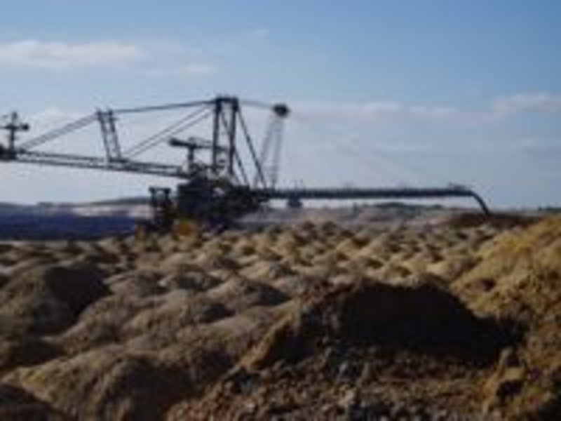
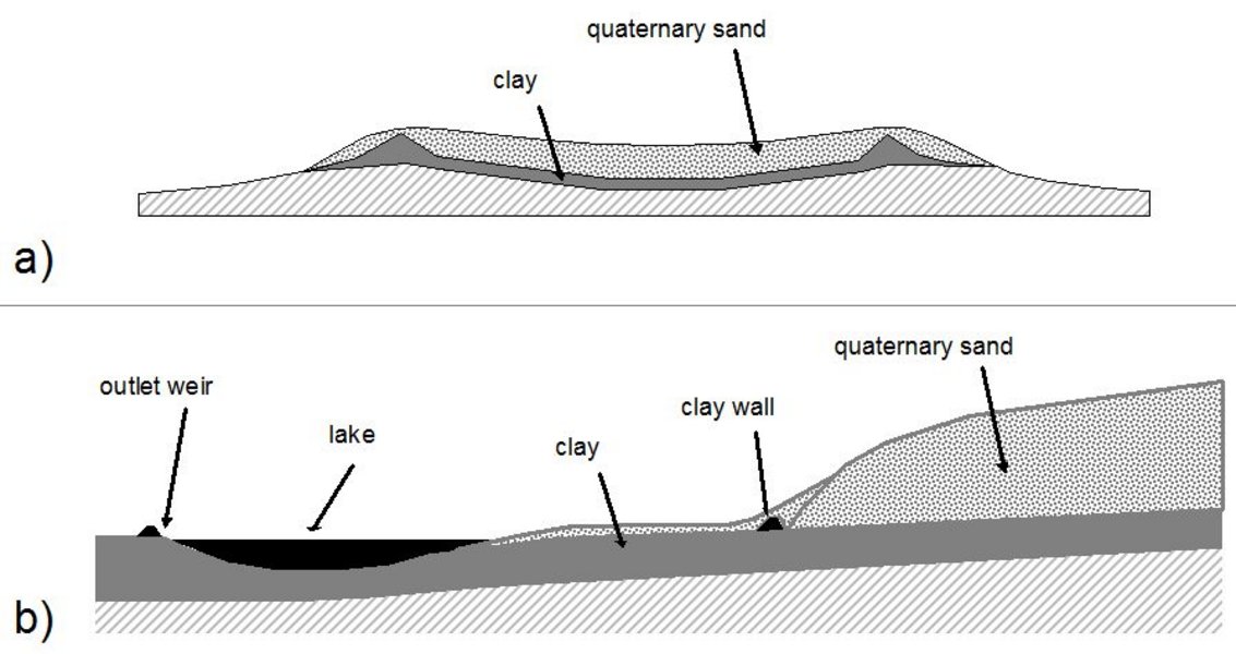
The construction works were carried out by large mining devices such as conveyor belt systems with bucket wheel excavators and a coupled stacker. A base layer of 1 to 3 m in thickness, consisting of Tertiary clay, was dumped and flattened as a barrier for seepage water. This clay material (from local geological layers identified as "Flaschentone") was separated from the overburden layers by bucket wheel excavators and dumped by a stacker. The clay surface was leveled by caterpillars but not additionally compacted since this clay material tends to self-sealing processes due to considerable swelling. Thus, the water permeability of the clay layer is very low. The surface of the clay layer was shaped as a shallow basin ascending from the centre to the edges to form the subsurface boundary for the catchment. The slope of the clay layer with an average inclination of 3 % is parallel to that of the surface area.
In the underground section of the lower part of the catchment additional clay walls were constructed on top of the clay layer running transversal to the slope, both as a stabilization barrier to prevent the sandy substrates from sliding downhill upon the clay layer, and additionally as a central discharge unit for groundwater in order to create an artificial well for the reconstructed creek. In addition, the construction plan allowed for the establishment of a small lake at the lowest part of the catchment with a diameter of around 70 m and a maximum depth of 3 m. A clay wall at the southern side of the lake defines the lower border of the catchment with one single defined outlet.
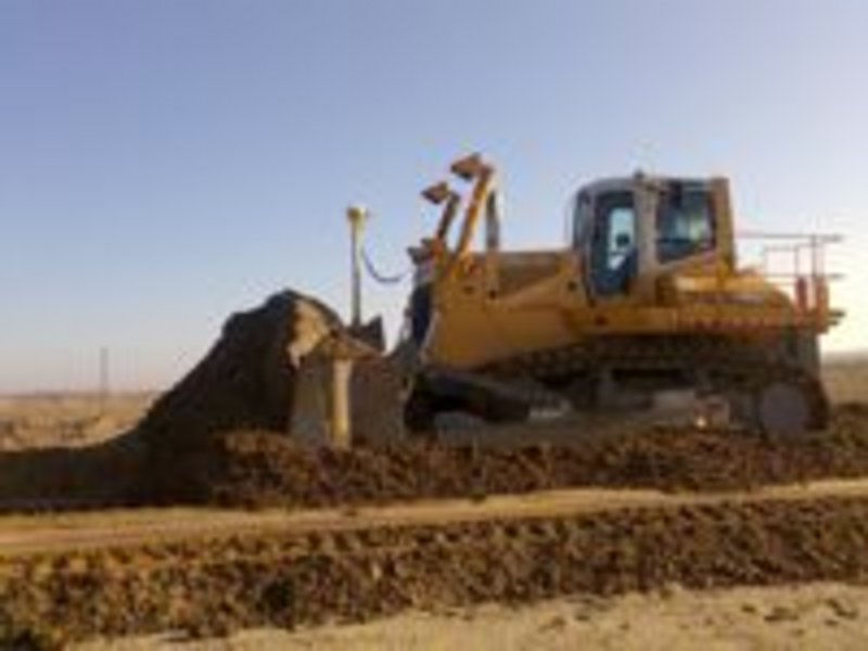
On top of the clay layer a sandy substrate was dumped with a thickness of up to 3.5 m. This was designated as aquifer so that a local groundwater body might develop. The sandy material stems from Pleistocene sediments taken from the forefield of the mine where it was deposited during the Saale-glacial period as a terminal moraine. In the lower parts of the site the sandy layer was spread up to close to the edge of the lake. Due to the dumping process this sandy layer is structured below the ground in the form of cones with a width of 3 to 4 m at their base. After dumping, the upper part of the cones was leveled by caterpillars and the surface of the site was flattened and homogenized using rails pulled by tractors. With this last treatment the surface formations stemming from the construction works such as car tracks were removed and a basin was formed to define the final surface boundaries of the catchment.
Structural elements
The catchment with an area of about 6 ha (400 x 150 m) has been laid out as a slight hill with an altitude difference of about 15 m along the main axis and the absolute heights ranging from 125 m a.s.l. at the outlet, up to 140 m a.s.l. The average longitudinal slope is 2-3 %; the exposition is SE.
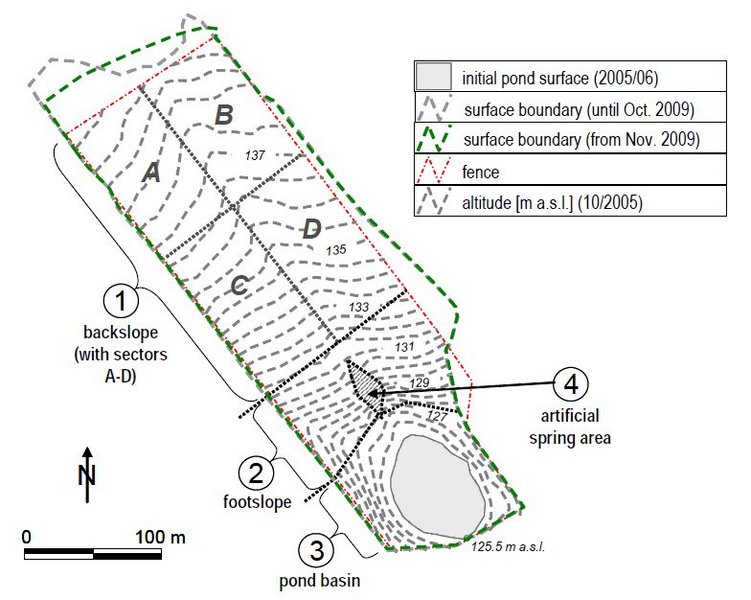
Generally, the catchment can be divided into four major sections:
(1) the backslope area which covers most of the site,
(2) the footslope with a steeper inclination,
(3) the lake basin with the single outlet of the watershed, and
(4) the spring area (place of the originally planned artificial spring).
Downstream the catchment is connected to the "Hühnerwasser" stream to be restored later on.
The site was fenced in completely to avoid disturbance and vandalism particularly by human visitors but also by the abundant game animals of this area. The construction operations were completed in September 2005 which is therefore defined as the "point zero" of the ongoing development of the site.
Since then the site has been left for an unrestricted and unmanaged succession. Neither amelioration measures such as fertilization and liming nor artificial re-vegetation have been applied. Erosion and other surface forming processes were allowed to ensue without any restriction. It is for this reason that the artificial catchment offers high potential for ecological investigations, as only initial substrate conditions as well as natural inputs to the area will control this very first stage of development.